We’ve tweaked our trip since we first conceived the route, based largely on what the people who live in or regularly visit the areas.
On Wednesday, we were out at the west end of the island, and today we will explore the east end. Still working out of our base at Mindemoya Court Cottages and Campgounds, our escorts will meet up with us in the morning and take us out and about.
We’re going to meander, and the actual route is up to our (spirit?) guides, but we KNOW we’re including these elements…
Mid-island, there the Bridal Veil Falls in Kagawong. It’s a hike, but you can make it short of long. We’re told that lots of riders do it in their gear. Once at the falls, you can take a dip, and even get behind the curtain of water in the falls!
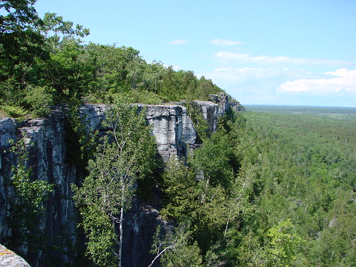
East of there is the famous Cup-and-Saucer trail. Part of the Niagara Escarpement, this is the highest point of land on the Island and offers an INCREDIBLE view. It’s another hike that we’re told bikes do all the time. We’ll check it out and let you know!
Still further east is the First Nations town of Sheguiandah. Here, at Ten Mile Point, is an incredible view east across the top of Georgian Bay to Killarney. We’ll continue south and east to Wikwemikong, the largest unceded First Nations community. Up the peninsula on Rabbit Island Road we’ll come to another scenic vista.
We’ll head back to our Campground, but before stopping for the day, we will head to Providence Bay. This is home to a magnificent sand beach, complete with boardwalk.
Manitoulin is rich in First Nations history and throughout nthe year there are events and PowWows. We’ll get a taste of the geography and culture in our brief visit, and we’ll tell you the story so you can choose how to spend your time.